
Choose the correct option
Question 1
The imaginary lines running east to west on a globe are called ............... while those running north to south are called ................ .
- Latitude, Longitude
- Longitude, Latitude
- Equator, Prime Meridian
- All of the above.
Answer
Latitude, Longitude
Question 2
Name the criss-crossing lines on a globe that form a framework.
- Geographic Framework
- Geographic Grid
- Geographic Matrix
- Geographic Lines
Answer
Geographic Grid
Question 3
Which of the following is true about the lines of Latitude?
- They are imaginary lines
- They are parallel to the Equator
- They reduce in length as we go towards the poles.
- All of the above.
Answer
All of the above
Question 4
Which of the following is true about lines of longitude?
- They run parallel to the Prime Meridian.
- They are full circles
- They are 360 lines at 1° interval.
- All of the above.
Answer
They are 360 lines at 1° interval.
Question 5
The distance between two lines of longitude is maximum at which latitude?
- Tropic of Cancer
- North Pole
- Equator
- Arctic circle
Answer
Equator
Question 6
The Earth has been divided into how many Time Zones?
- 48
- 20
- 12
- 24
Answer
24
Question 7
What is Standard Time?
- Uniform time based on a central meridian.
- Time at 0° longitude
- Time at 82°30'E
- Time at 7½° longitudes at 12 noon.
Answer
Uniform time based on a central meridian
Question 8
Which of the following is true about the International Date Line?
- It goes zig-zag at two points.
- The date changes as one moves across it.
- It is opposite the Prime Meridian.
- All of the above.
Answer
All of the above
Question 9
A great circle is a circle drawn on the surface of a sphere with radius :
- equal to the radius of the sphere.
- equal to half the radius of the sphere.
- larger than the radius of the sphere.
- less than the radius of the sphere.
Answer
equal to the radius of the sphere
Question 10
Which of the following are great circles?
- Lines of Longitudes
- Lines of Latitudes
- Equator
- Both (1) and (3)
Answer
Both (1) and (3)
Question 11
In each hemisphere for which latitude the length of the circle is half the length of the Equator?
- 30°
- 45°
- 60°
- 90°
Answer
60°
Question 12
The total number of the parallels of Latitude are ................ .
- 180
- 182
- 183
- 181
Answer
181
Question 13
The poles are located at what angular distance from the Equator.
- 90°
- 45°
- 60°
- 0°
Answer
90°
Question 14
The length of the Equator is equal to:
- 40,075 km
- 40,750 km
- 40,250 km
- 40,525 km
Answer
40,075 km
Question 15
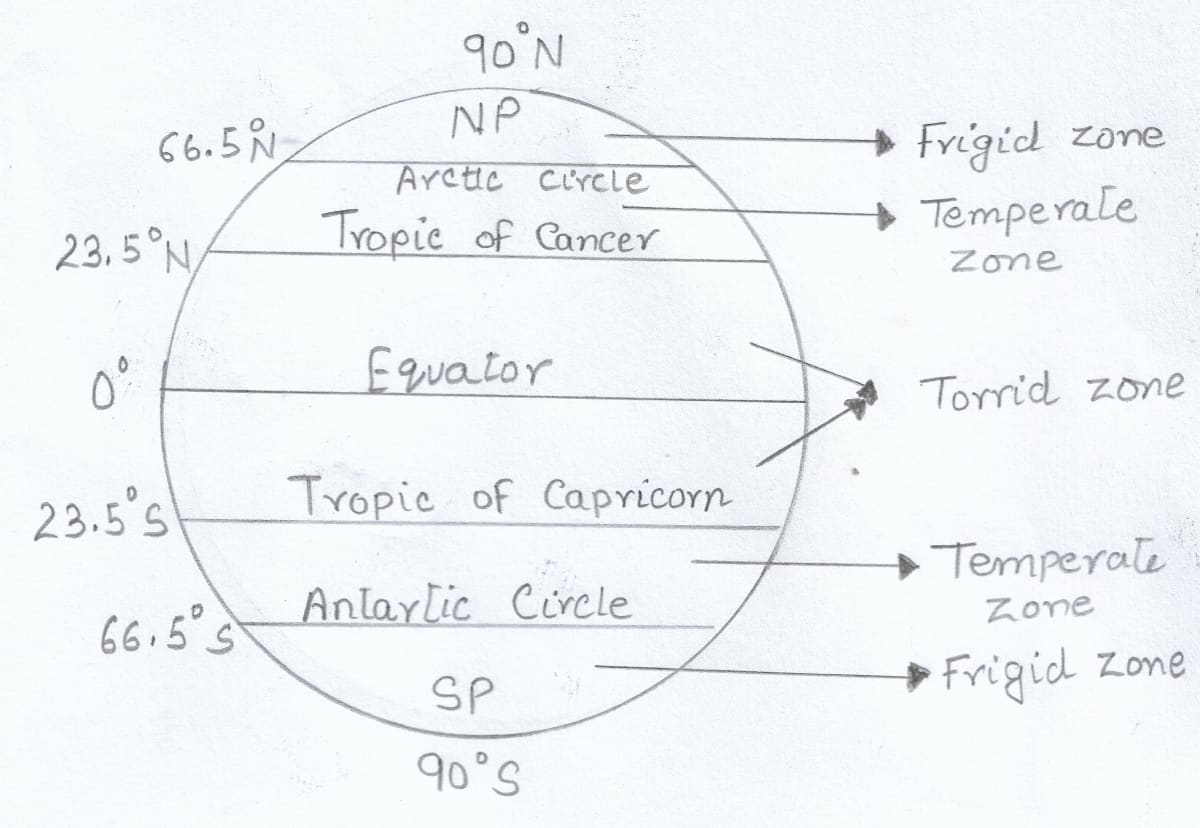
Which of the following heat zones are correct?
- Frigid Zone: 66½°N to 66½°S
- Temperate Zone: 90°N to 90°S
- Torrid Zone : 23½°N to 23½°S
- All of the above.
Answer
Torrid Zone : 23½°N to 23½°S
Short Answer Questions
Question 1
What is a geographic grid? How does the geographic grid serve the same purpose as co-ordinates on a graph?
Answer
A framework of lines of longitude and latitude on a globe or a map is called a geographic grid.
This grid on the globe or the map serves the same purpose as the system of coordinates on the x-axis and y-axis on a graph paper. In this case the x-axis is represented by lines of latitude (horizontal) and y-axis, by lines of longitude (vertical). These lines help to locate places on the globe.
Question 2
What are lines of latitude and longitude? Who devised the lines of latitude and longitude?
Answer
The imaginary lines running east to west, parallel to the equator are called lines of latitude.
The imaginary lines running north to south passing through the poles are called lines of longitude.
Eratosthenes, the Greek philosopher, devised the lines of latitude and longitude.
Question 3
Mention two characteristics of lines of latitude.
Answer
Two characteristics of lines of latitude are:
- Lines of latitude are imaginary lines joining all places having the same latitude towards north or south of the equator.
- A latitude is marked in degrees, with equator being 0 degrees.
Question 4
Name the two hemispheres of the earth made by the Equator. Name the thermal zones of the earth.
Answer
The two hemispheres of the earth made by the Equator are-
- Northern hemisphere
- Southern hemisphere
The thermal zones of the earth are-
- Torrid or Tropical zone
- Temperate zone
- Frigid zone
Question 5
List any two uses of the lines of latitude. Express 1° angular distance in kilometres.
Answer
Two uses of the lines of latitude are:
- To find the location of a Place — Latitudes give us the location of a place north or south of the Equator. Such a location is known as an absolute location.
- To measure the distance of a Place — Distances are calculated with reference to the Equator at right angle to the place. We can therefore, measure the distance of any place from the Equator based on its degree of latitude.
The angular distance of 1° latitude is equal to 111 km.
Question 6
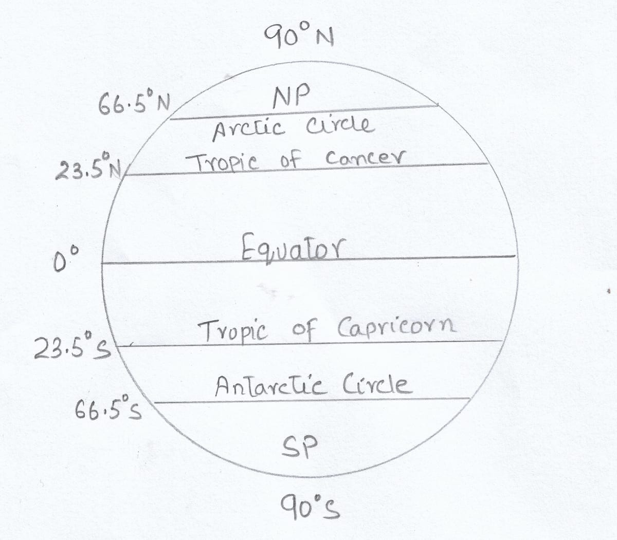
With the help of a diagram, show the important lines of latitude.
Answer
Question 7
Briefly describe the cycle of seasons with the change in inclination of the sun's rays. Which temperature zone receives almost vertical rays of the sun and which zones receive slanting rays?
Answer
The cycle of seasons is determined by the change in the angle of the sun's rays hitting the earth's surface, which is caused by the earth's axial tilt of approximately 23.5 degrees. As the earth orbits the sun, different parts of the earth are tilted towards or away from the sun at different times of the year, resulting in the four seasons.
Torrid zone receives almost vertical rays of the sun and temperate zone and frigid zone receive slanting rays of the sun.
Question 8
Which line is known as the Prime Meridian? State its importance.
Answer
The Prime Meridian is the line of longitude whose angular distance is defined as 0 degrees. It passes through Greenwich near London.
While fixing the Time Zones, the time at Prime Meridian has been selected as the mean time. The time for all the other places is calculated with reference to the time at Prime Meridian.
Question 9
How can the general climate of an area be described with the help of the lines of latitude?
Answer
Lines of latitude divide the earth into three distinct heat belts -
- Torrid zone, being the hottest zone
- Temperate zone with moderate climate
- Frigid zone with the coldest climate
The lines of latitude indicate the general climate of the area by applying the principle of heat zones of the earth.
Question 10
Which line of longitude is used to fix the World Standard Time? State its value in degrees. State the longitudinal value in degrees of Indian Standard Meridian.
Answer
Prime Meridian is used to fix the World Standard Time.
Its value in degrees is 0°.
The longitudinal value of Indian Standard Meridian is 82° 30'E.
Question 11
List any two characteristics of the Great Circles.
Answer
Two characteristics of the Great Circles are:
- All such circles must pass through or touch the centre of the circle.
- Infinite number of circles that touch the two opposite ends of the sphere can be drawn on a sphere.
Question 12
List any two uses of the Great Circles.
Answer
Two uses of the Great Circles are:
- Great Circle routes are specially important for places that are on opposite sides of the globe. Most globes show great circle routes between distant ports across the Atlantic, the Pacific and the Indian Ocean.
- Great circles are used by meteorologists to determine climate and weather conditions in a region.
Question 13
What are the Great Circle Routes? State their importance.
Answer
A great circle route is the shortest distance between two places on the earth and lies on the arc of a great circle.
Great Circle Routes are specially important for places that are on opposite sides of the globe.
Structured Questions
Question 1(a)
State the five lines of latitude.
Answer
The main five lines of latitude are-
- Equator (0°)
- The Tropic of Cancer (23.5° N)
- The Tropic of Capricorn (23.5° S)
- The Arctic circle (66.5° N)
- The Antarctic circle (66.5° S)
Question 1(b)
What is the significance of these lines of latitude?
Answer
These lines of latitude form one of the coordinates of the grid system. The lines of latitude have the following significance-
- They are used to find the location of a place
- They are used to measure the distance of a place
- They divide the earth into distinct heat zones
Question 1(c)
Give a geographical reason for each of the following:
(i) Lines of latitude are called parallels of latitude.
(ii) Lines of latitude are not of equal length.
(iii) Lines of latitude carve out the heat zones of the earth.
Answer
(i) Lines of latitude are called parallels of latitude as these lines are parallel to the Equator and each other.
(ii) Lines of latitude are not of equal length as they become smaller as we move towards the poles.
(iii) Lines of latitude carve out the heat zones of the earth as the temperature goes on decreasing from the equator towards the poles. Thus, these lines indicate the general climate of an area by applying the principle of heat zones.
Question 1(d)
Draw a well labelled diagram showing the different heat zones of the world.
Answer
Question 2(a)
Describe the lines of longitude.
Answer
The imaginary lines running north to south passing through the poles are called lines of longitude.
Question 2(b)
State the use of the lines of longitude in relation to distance and time.
Answer
The earth makes a complete circle on its axis covering 360° in 24 hours. It covers 1° longitude every 4 minutes. For each 1° longitude towards the east, 4 minutes are to be added and for each 1° longitude towards the west, 4 minutes are to be subtracted.
Question 2(c)
Give a geographical reason for each of the following:
(i) Lines of longitude are called meridians of longitude.
(ii) Lines of longitude are of same length.
(iii) Diametrically opposite lines of longitude and the Equator are called Great Circles.
Answer
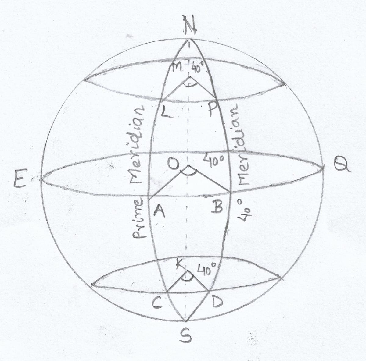
(i) Lines of longitude are called meridians of longitude because the sun crosses a meridian at noon. So, all places on a particular meridian will have noon at the same time.
(ii) Lines of longitude are of same length as they all converge at the poles.
(iii) Diametrically opposite lines of longitude and the Equator are called Great Circles because they pass through or touch the centre of the circle. Also, they have a radius equal to the radius of the sphere's centre.
Question 2(d)
Draw a well labelled diagram to show that places on the same longitude have the same time.
Answer
Question 3(a)
State the meaning of the International Date Line.
Answer
The line of longitude 180° is one and the same for east or west of the Prime Meridian. Since it is diametrically opposite to the Greenwich Meridian, it causes a time difference of a full day on crossing the line.
The International Date Line is the 180° line. When crossing this date line from the west to east a day is deducted or the time is fixed backward by one day. When crossing the International Date Line, from east to west, a day is added.
Question 3(b)
State with an example how time lost or gained is computed with reference to the International Date Line.
Answer
The International Date Line is the 180° line. When crossing this date line from the west to east a day is deducted or the time is fixed backward by one day. When crossing the International Date Line, from east to west, a day is added.
For example, if it is 8 pm Monday 25th December at Greenwich, it will be 8 am Tuesday, 26th December on crossing the 180° line from the east as time will be 12 hours ahead. But if one were to travel from west, it will be 12 hours behind or 8 am Monday, 25th December.
Question 3(c)
Give a geographical reason for each of the following:
(i) The International Date Line deviates and goes zig-zag near some islands in the Pacific Ocean.
(ii) The Greenwich time is called the Greenwich Mean Time.
(iii) Great Circles are the shortest routes between two places.
Answer
(i) The International Date Line deviates and goes zig-zag near some islands in the Pacific Ocean to avoid the confusion of having different dates within the same country.
(ii) The Greenwich time is called the Greenwich Mean Time as while fixing the time zones, the time at Greenwich has been selected as the mean time and provides the basis for calculating the Standard Time of other places.
(iii) Great Circles are the shortest routes between two places as we can connect any two places on the earth's surface by the curvature line of the great circle. And this curvature is the smallest possible route between those two places, because this curvature directly connects those places or points.
Question 3(d)
State with one practical example how is time of a place found with the help of longitudes.
Answer
As the earth takes 24 hours to make a complete rotation along its axis crossing 360° lines of longitude, so earth takes nearly 4 minutes to move 1° longitude.
For example, Indian Standard Time is based on 82 1/2° E longitude. So if the time in India is 12 noon, so it will be 6.30 A.M. in England or GMT.
The time difference between 0° and 82 1/2° E will be-
82.5 × 4 = 330 minutes or 330 ÷ 60 = 5 1/2 hours
So there is difference of 5 1/2 hours between India and England, as England lies in the west, so the time will be 5 1/2 hours less than India.
Thinking Skills
Question 1
Find the latitude of your city and state how has this influenced the climate of your city.
Answer
The latitude of my city is 26° 55' N.
My city lies in the North Temperate zone which is between 23½°N to 66½°N. This region experiences moderate climate i.e., the temperature is neither too hot nor too cold.
Question 2
Your home town is located at a place which receives the slanting rays of the sun. How is the temperature of your home town different from your boarding school, located at a place that receives the vertical rays of the Sun?
Answer
My home town is located near the poles as it receives slanting rays of the sun. Slanting rays lose more heat while travelling and result in cooler temperature. On the other hand, my boarding school is located near the equator as it receives vertical rays of the sun resulting in higher temperature.
Question 3
Find out the name of the country which has the maximum number of time zones in the world. What is reason behind a country having many time zones and others like India have just one time zone.
Answer
Russia has the maximum number of time zones in the world, with a total of 11 time zones. The reason behind a country having multiple time zones is due to its geographical size and location. As the earth rotates, each 15° change in longitude corresponds to a one-hour difference in time. Therefore, a country that spans several longitudes, like Russia or the United States, may have multiple time zones to account for the variations in local time.
In the case of India, the country is geographically smaller and spans fewer longitudes compared to a country like Russia. Therefore, India has one time zone to maintain uniformity across the country.
Question 4
When you were waiting to welcome New Year in India on December 31, some countries of the world like Australia, New Zealand and Japan have already welcomed New Year. What is the reason for this?
Answer
Some countries like Australia, New Zealand, and Japan welcome the New Year before India because of the differences in time zones. These countries are located ahead of India in terms of longitude, and therefore, they are several hours ahead in time.
Australia and New Zealand are located in the eastern hemisphere and are ahead of India in terms of time zones. Japan is located in the same time zone as Australia and also welcomes the New Year before India.
Project/Activity
Look at the map of the Time Zones (Fig. 2.7) and answer the following questions:
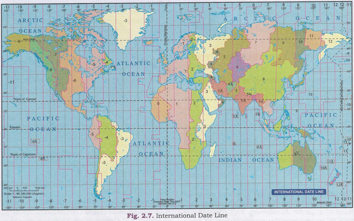
Question 1
What is the Longitudinal degree of IST?
Answer
82 1/2° E
Question 2
If it is 2 a.m. IST, what will be the Time at Tokyo, London, San Francisco?
Answer
Tokyo - 5:30 am
London - 9:30 pm
San Francisco - 1:30 pm
Question 3
Name the place which is diametrically opposite of India.
Answer
Chile is diametrically opposite of India.
Question 4
Is the Indian Standard Time ahead of San Francisco Time? Give reasons for your answer.
Answer
Yes, Indian Standard Time is ahead of San Francisco Time as India is 5:30 hrs ahead of GMT while San Francisco is 7:00 hrs behind GMT.